As regards to objective (1), arguments in favour of coordinated ground and space observations of the ionosphere-magnetosphere have had currency since spacecraft exploration began. Ground radars operate through finite time intervals to produce integrated images of the spatial distribution of various parameters. Spacecraft move relatively quickly through part of the radar coverage yielding snapshots of the same parameters. Brought together, these two data sets permit us to understand the complete spatial-temporal behaviour of atmospheric dynamics.
There are objectives adequately addressed with ground facilities alone. Data from incoherent backscatter, coherent HF backscatter and ground ionosondes when compared yield consistent measurements of certain quantities, for instance the drift velocity of the convecting ionospheric plasma. These parameters tend to be of the bulk-parameter or large-scale variety. However, other scientific objectives unavoidably require in-situ, space observations. These include micro-scale observations of plasma processes in general, and, in the context of EM wave spectrum, observations of wave parameters which simply are not accessible from the ground. Objectives (1) and (2) exploit the potential of a tethered payload for these two kinds of in-situ observations.
Objective (3) is a unique and novel method for tomography of the ionosphere, which would be done with orbiting GPS receivers that are necessary for objectives (1) and (2).
Investigation of Density Irregularities using Coordinated Space and Ground Measurements
The high-latitude ionosphere can have a dramatic effect on EM waves passing through it. Waves can be refracted, scattered, amplified or damped depending on the local state of the medium. In the area of coherent backscatter at High Frequency (HF, 3-30 MHz), facilities like the SuperDARN radar have been designed to provide hemisphere-wide maps of the plasma convection. The interpretation of HF scatter has been based on hypotheses of ray-optics propagation to/from regions of irregularity where aspect-sensitive scatter returns some of the incident wave energy back to the radar. These hypotheses are important in the assumed relation of the characteristics of the scatterers to the overall motion of the medium.
It has been difficult to test scattering hypotheses. We take up this challenge by planning coordinated studies of BOLAS and the ground facilities SuperDARN and the Canadian Advanced Digital Ionosondes (CADIs). Our studies are aimed at giving an ionospheric perspective on the details of scattered HF waves. The BOLAS synchronized radio receivers will record ground-originating signals, and onboard sensors will detect the density structure on the field lines near the apparent scattering source(s). Wave parameters analyzed will include signal amplitude, delay and direction of arrival (DOA). The latter two parameters would be made possible by synchronization through the GPS.
Wave processes at F-region heights will be investigated, principally coherent scatter and refraction, happening between ground radars and observing spacecraft. The radar waves probe irregularity structures that result from fluid instabilities of the F-region plasma. The structures are normally assumed to be aligned with B and to extend to altitudes of the BOLAS orbit. HF radar work, and therefore this mission, are mainly focussed on the F region because the cross-section for coherent scatter maximizes there, on account of a combination of plasma-physical and radio-wave propagation factors.
The figure below illustrates the relationship of ground facilities, the BOLAS spacecraft and ionospheric targets. A ground HF radar, e.g. SuperDARN, irradiates the E and F regions of the high-latitude ionosphere. The radar receives backscatter from density irregularities in both the E and F regions. F-region scatter can be detected on direct paths like "d" and from one-hop paths like the dotted line just below the d path that involve an oblique F-reflection and a subsequent ground-reflection before backscatter from ionospheric irregularities located beyond the right side of the diagram. GPS-based synchronization permits the data analyst to determine the scattering direction. The intensity of scattered, or of smoothly propagated, radar waves is followed as a function of the position of the orbiting receiver, giving information about the angular distribution of the scatter. Oblique scatter may be detected in both the forward and backward directions, corresponding to the right-side and left-side locations of BOLAS in the figure, respectively.
The BOLAS double receiver coordinated with ground radars and ionosondes.
The direction, delay and amplitude of ionospheric waves:
The inherent accuracy of GPS-based clocks permits phase-path difference measurements with two conventional radio receivers up to at least High Frequency (3-30 MHz). Real beam forming can be applied confidently to manmade waves from ground transmitters, and possibly to some kinds of spontaneous electromagnetic waves.
An analysis of the tethered two-element direction finder yields conservative estimates of the error in DOA of about 5% at HF. Wave front curvature, arising when the spacecraft is too close to a scattering source, is not anticipated to be a problem, given the scale of satellite-source distances in relation to the beam pattern of SuperDARN transmitters. However, it is not obvious before the experiment that sources would have point dimensions as seen from the spacecraft, rather than subtending a finite solid angle. This check would have to await the actual mission.
Three-dimensional DOA measurements are made in space using three-axis antenna-receiver systems on single spacecraft. Examples are DE-1 and the recently launched Global Geospace Science spacecraft GEOTAIL, WIND and POLAR. BOLAS is not intended to compete with these observatory-class spacecraft. They observe spontaneous wave sources from great distances. As distinct from the BOLAS one-dimensional measurement of direction which can be supplemented with contextual information, such as the location of the ground transmitter, those space experiments are designed to locate unambiguously sources that can lie anywhere. By virtue of its 100-m baseline, BOLAS has the interferometer advantage of better DOA resolution.
Coordinated experiments with the SuperDARN radar:
One of the major opportunities provided by BOLAS is its DOA measurement. In its "interferometer" mode similarly mesasures the elevation angle of the received rays. By identifying the propagation direction, SuperDARN thereby distinguishes among direct, one-hop or two-hop paths to the scattering region. At the BOLAS satellite, a particular mode would be readily identifiable by its elevation angle. Thus a clear picture of propagation paths will be obtained from the amalgamated ground and satellite DOA data sets.
Other novel observing opportunities will be observing phased wave fronts inside scattering volumes; measuring density gradients when traversing ionospheric structures like polar patches or auroral arcs; encountering smaller scale density structures due to electron precipitation; studying gravity waves; and observing the double-peaked Doppler spectra produced in regions of intense soft-electron precipitation.
Coordinated experiments with the CADI ionosondes:
We envisage passes of BOLAS over the CADIs, whose beams are centred on the vertical. Orbital motion would allow BOLAS to sweep a range of ray directions and thereby probe the shape of F-region localized structures such as ionospheric "blobs" or gravity waves. The figure below shows the results of a simulation of the raypaths, for a typical high latitude blob, from a ground transmitter to the topside ionosphere. The rays are at 1° increments of elevation angle. A number of effects can be seen: focusing of energy (where the raypaths are close together), angular deviation of the rays, group delay effects (the tic marks on the rays show the time elapsed) and multiple raypaths to the satellite height (with different time delays). The raypath picture is found to be sensitive to the relative geometry, probing frequency, and electron densities. Thus, measuring the amplitude, angle of the rays, and the time delays from the topside satellite pair should allow us to get a reasonably sensitive fit to ionospheric structures. In the course of analysis, we would expect to ascertain whether this fitting is best done by sorting through a library of simulated results, or through a more analytical approach.
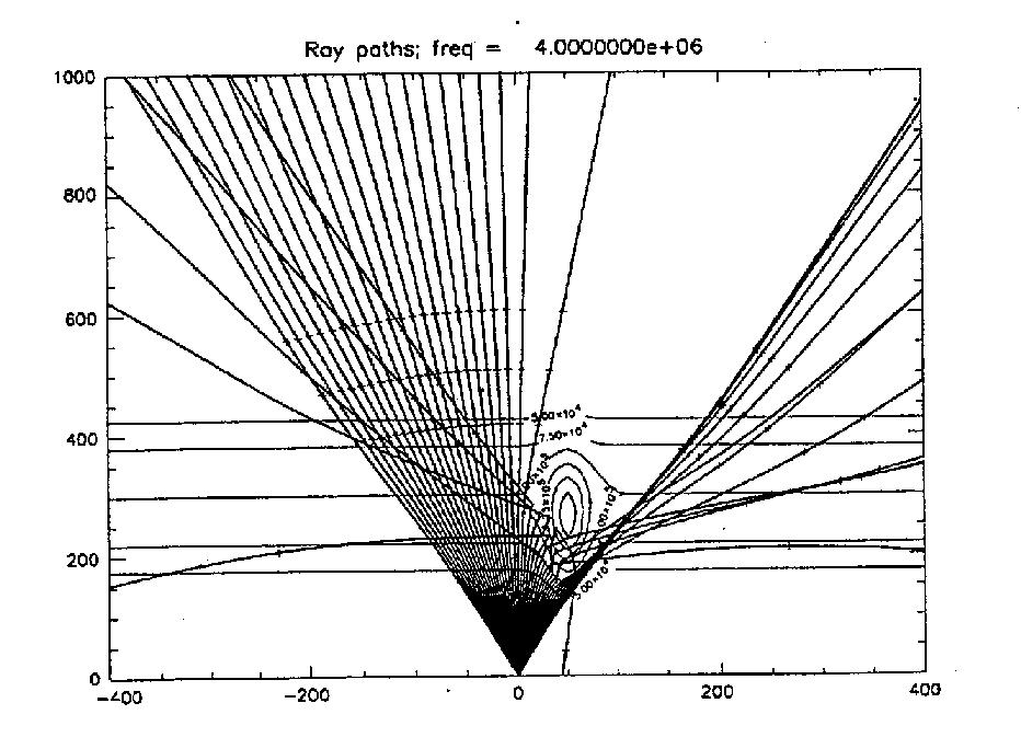
Rays traced from a CADI ionosonde through an ionospheric F-layer model in which an auroral blob density enhancement is embedded.
Measurement of Auroral Wave-particle Interactions
The flight of a tethered pair of satellites instrumented for field and particle detection presents a unique opportunity for space plasma research when the separation of the two bodies is about 100 m. Scale sizes of this order of magnitude are found in reports of spontaneous wave structures. We shall therefore exploit the 100 m separated instrument pair to compare particle and wave parameters measured simultaneously across this separation. This will lead to improved models of localized plasma instability.
The two-point BOLAS measurements would provide new information on both wavelength and spatial extent. Localized density cavities are associated with ion heating in the nightside auroral zone. The scale size of these cavities is of the same order as the 100 m BOLAS separation. Identical particle sensors on each of the spacecraft will make novel measurements of the spatial/temporal properties of these cavities, and of the state of the low-energy plasma distribution within them. VLF (3-30 kHz) lower hybrid waves are a good example, as they are known to occur as "spikelets" concentrated on scales of the order of 50 m, and result in localized ion heating.
The importance of shears in the plasma electric field and convection velocity in driving instability and plasma outflow has recently become appreciated. Typically, it is difficult to determine whether observed features in the convection pattern are spatial or temporal in nature. In resolving such ambiguities, BOLAS two-point measurements may shed light on the generation of shear-assisted instabilities. The use of thermal ion and electon detectors to measure field-aligned current adds to the capability.
The Freja satellite mission has revealed an pertinent ELF phenomenon (below 3 kHz): Solitary Kinetic Alfvén Waves (SKAW). These waves are localized on scales of hundreds of meters. They may also generate localized ion heating, although this point awaits definitive experimental verification, hopefully by BOLAS. By traversing localized heating structures with two spatially separated probes, we will learn much about their form and dimensions and as a consequence clarify their normal modes and sources of free energy. Highly localized velocity shears can drive broad-band ELF waves observed within SKAW and can strongly affect their dispersion characteristics.
Ionospheric Tomography based on Occultation of GPS Signals
Terrestrial GPS receivers currently measure total electron content (TEC) on different horizontal scales. The GPS-derived TEC at ground stations can be used to build two-dimensional global zenith TEC maps through interpolation with empirical models, such as the International Reference Ionosphere 1995 (IRI95). Such descriptions of the ionosphere are limited by the resolution of these maps, which among other factors is a function of the number of ground stations used in the interpolation, by the land-bound nature of these stations, and by the absence of information on vertical electron density distribution.
We plan to remove these limiting factors, through spaceborne GPS receivers observing the same signals as the terrestrial receivers. By having the GPS receiver(s) track GPS satellites rising or setting relative to a host spacecraft, in this case the low earth orbiter (LEO) BOLAS, vertical profiles of electron density can be determined when the signals cut through the ionosphere. The phase and amplitude of the L1 and L2 GPS signals are affected in ways that are characteristic of the index of refraction of the ionosphere. These effects can be interpreted geometrically as bending of the GPS signals. The radio occultation geometry is illustrated in the figure below.
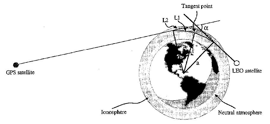
The radio occultation geometry. Alpha is the occultation bending angle, a is the impact parameter, and r is the radius to the ray pariapsis tangent point. L1 and L2 are the GPS Link 1 and Link 2 frequencies, respectively. In the case pf the BOLAS-GPS links, this diagram greatly exaggerates the amount of L1 and L2 bending: alpha values of less than 0.01 degrees are expected.
Current ionospheric occultation methodologies call for the atmosphere to be composed locally of spherical, symmetrical shells, each shell having a uniform index of refraction. The estimate of the bending of the occulting signal is then derived from isolating the excess Doppler shift induced by the atmosphere. This excess Doppler shift is the difference between the measured Doppler shift by the BOLAS GPS receiver of an occulted GPS satellite and the computed, theoretical, "occultation-free" Doppler shift that would have been observed at the BOLAS GPS receiver. This latter quantity is derived from a precise orbit determination (POD) of the LEO, utilizing measurements made with the LEO GPS receiver of unocculted GPS satellite L1 and L2 signals. From the BOLAS and GPS POD information, the theoretical Doppler shifts can be derived. An Abel integral transform is used to derive the index of refraction from the bending. The electron density along the ionospheric profile can then be determined from a high-frequency approximation to the Appleton-Hartree formula for the index of refraction.
The combination of such spaceborne data and terrestrial data will allow for high resolution two- and three-dimensional tomography as depicted in the figure below. This level of spatial and temporal coverage for the global ionosphere can not presently be provided by any single technique. It is therefore planned that terrestrial GPS-based ionospheric profiling be used in combination with the spaceborne occultation technique to provide three-dimensional ionospheric imaging.
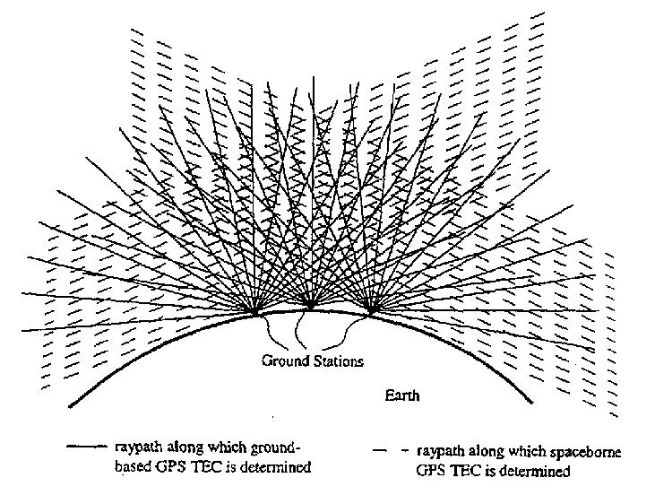
High resolution two- and three-dimensional ionospheric tomography based on combined ground and spaceborne GPS receiver measurements.
The BOLAS double receiver coordinated with ground radars and ionosondes.
The inherent accuracy of GPS-based clocks permits phase-path difference measurements with two conventional radio receivers up to at least High Frequency (3-30 MHz). Real beam forming can be applied confidently to manmade waves from ground transmitters, and possibly to some kinds of spontaneous electromagnetic waves.
An analysis of the tethered two-element direction finder yields conservative estimates of the error in DOA of about 5% at HF. Wave front curvature, arising when the spacecraft is too close to a scattering source, is not anticipated to be a problem, given the scale of satellite-source distances in relation to the beam pattern of SuperDARN transmitters. However, it is not obvious before the experiment that sources would have point dimensions as seen from the spacecraft, rather than subtending a finite solid angle. This check would have to await the actual mission.
Three-dimensional DOA measurements are made in space using three-axis antenna-receiver systems on single spacecraft. Examples are DE-1 and the recently launched Global Geospace Science spacecraft GEOTAIL, WIND and POLAR. BOLAS is not intended to compete with these observatory-class spacecraft. They observe spontaneous wave sources from great distances. As distinct from the BOLAS one-dimensional measurement of direction which can be supplemented with contextual information, such as the location of the ground transmitter, those space experiments are designed to locate unambiguously sources that can lie anywhere. By virtue of its 100-m baseline, BOLAS has the interferometer advantage of better DOA resolution.
Coordinated experiments with the SuperDARN radar:
One of the major opportunities provided by BOLAS is its DOA measurement. In its "interferometer" mode similarly mesasures the elevation angle of the received rays. By identifying the propagation direction, SuperDARN thereby distinguishes among direct, one-hop or two-hop paths to the scattering region. At the BOLAS satellite, a particular mode would be readily identifiable by its elevation angle. Thus a clear picture of propagation paths will be obtained from the amalgamated ground and satellite DOA data sets.
Other novel observing opportunities will be observing phased wave fronts inside scattering volumes; measuring density gradients when traversing ionospheric structures like polar patches or auroral arcs; encountering smaller scale density structures due to electron precipitation; studying gravity waves; and observing the double-peaked Doppler spectra produced in regions of intense soft-electron precipitation.
Coordinated experiments with the CADI ionosondes:
We envisage passes of BOLAS over the CADIs, whose beams are centred on the vertical. Orbital motion would allow BOLAS to sweep a range of ray directions and thereby probe the shape of F-region localized structures such as ionospheric "blobs" or gravity waves. The figure below shows the results of a simulation of the raypaths, for a typical high latitude blob, from a ground transmitter to the topside ionosphere. The rays are at 1° increments of elevation angle. A number of effects can be seen: focusing of energy (where the raypaths are close together), angular deviation of the rays, group delay effects (the tic marks on the rays show the time elapsed) and multiple raypaths to the satellite height (with different time delays). The raypath picture is found to be sensitive to the relative geometry, probing frequency, and electron densities. Thus, measuring the amplitude, angle of the rays, and the time delays from the topside satellite pair should allow us to get a reasonably sensitive fit to ionospheric structures. In the course of analysis, we would expect to ascertain whether this fitting is best done by sorting through a library of simulated results, or through a more analytical approach.
The two-point BOLAS measurements would provide new information on both wavelength and spatial extent. Localized density cavities are associated with ion heating in the nightside auroral zone. The scale size of these cavities is of the same order as the 100 m BOLAS separation. Identical particle sensors on each of the spacecraft will make novel measurements of the spatial/temporal properties of these cavities, and of the state of the low-energy plasma distribution within them. VLF (3-30 kHz) lower hybrid waves are a good example, as they are known to occur as "spikelets" concentrated on scales of the order of 50 m, and result in localized ion heating.
The importance of shears in the plasma electric field and convection velocity in driving instability and plasma outflow has recently become appreciated. Typically, it is difficult to determine whether observed features in the convection pattern are spatial or temporal in nature. In resolving such ambiguities, BOLAS two-point measurements may shed light on the generation of shear-assisted instabilities. The use of thermal ion and electon detectors to measure field-aligned current adds to the capability.
The Freja satellite mission has revealed an pertinent ELF phenomenon (below 3 kHz): Solitary Kinetic Alfvén Waves (SKAW). These waves are localized on scales of hundreds of meters. They may also generate localized ion heating, although this point awaits definitive experimental verification, hopefully by BOLAS. By traversing localized heating structures with two spatially separated probes, we will learn much about their form and dimensions and as a consequence clarify their normal modes and sources of free energy. Highly localized velocity shears can drive broad-band ELF waves observed within SKAW and can strongly affect their dispersion characteristics.
We plan to remove these limiting factors, through spaceborne GPS receivers observing the same signals as the terrestrial receivers. By having the GPS receiver(s) track GPS satellites rising or setting relative to a host spacecraft, in this case the low earth orbiter (LEO) BOLAS, vertical profiles of electron density can be determined when the signals cut through the ionosphere. The phase and amplitude of the L1 and L2 GPS signals are affected in ways that are characteristic of the index of refraction of the ionosphere. These effects can be interpreted geometrically as bending of the GPS signals. The radio occultation geometry is illustrated in the figure below.
Current ionospheric occultation methodologies call for the atmosphere to be composed locally of spherical, symmetrical shells, each shell having a uniform index of refraction. The estimate of the bending of the occulting signal is then derived from isolating the excess Doppler shift induced by the atmosphere. This excess Doppler shift is the difference between the measured Doppler shift by the BOLAS GPS receiver of an occulted GPS satellite and the computed, theoretical, "occultation-free" Doppler shift that would have been observed at the BOLAS GPS receiver. This latter quantity is derived from a precise orbit determination (POD) of the LEO, utilizing measurements made with the LEO GPS receiver of unocculted GPS satellite L1 and L2 signals. From the BOLAS and GPS POD information, the theoretical Doppler shifts can be derived. An Abel integral transform is used to derive the index of refraction from the bending. The electron density along the ionospheric profile can then be determined from a high-frequency approximation to the Appleton-Hartree formula for the index of refraction.
The combination of such spaceborne data and terrestrial data will allow for high resolution two- and three-dimensional tomography as depicted in the figure below. This level of spatial and temporal coverage for the global ionosphere can not presently be provided by any single technique. It is therefore planned that terrestrial GPS-based ionospheric profiling be used in combination with the spaceborne occultation technique to provide three-dimensional ionospheric imaging.